|
High-Precision RTK without the High Cost
ProMark™3 RTK offers complete real-time GNSS surveying and mobile mapping capabilities on an innovative platform at a remarkably affordable price.
Magellan’s embedded BLADE™ technology, a proprietary GNSS processing solution, enables ProMark3 RTK to outperform other single-frequency RTK receivers, granting real-time performance in the most lightweight handheld system on the market.
An outstanding new GNSS engine, BLADE technology delivers centimeter accuracy for real-time and post-processing surveys and mapping operations. BLADE’s unique GPS+SBAS RTK algorithm ensures quick initialization with single frequency receivers and takes full advantage of the maximum satellite coverage from the dual constellation.
With BLADE built in, ProMark3 RTK is feature rich, precise and reliable.
Based on an advanced, easy-to-use, easy-to-learn technology, ProMark3 RTK is rugged and reliable, offering precision performance even under difficult conditions. If you need an affordable, high-precision GNSS solution, YOU’VE GOT IT! -- with the most popular handheld survey system on the market; ProMark3 RTK. | 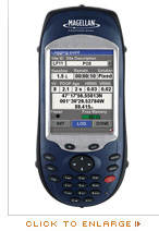 |
Expand Your Survey Potential
ProMark3 RTK offers superior GPS capability in a complete range of survey modes, including real-time, real-time + raw data, post-processing and mapping. Ideally suited for short baseline surveys, such as construction site, stake out, and cadastral, ProMark3 RTK is a high-performance positioning, GNSS and mapping solution.
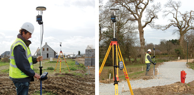
ProMark3 RTK System: Base + Rover
ProMark3 RTK is available as an all-inclusive Base + Rover system with a license-free plug-and-play radio kit. This provides a great advantage when a network is unavailable or when surveying independently from 3rd party data corrections.
The integrated radios conform to the IP65 standard and are directly powered from the receiver and easily configured through a simple menu.
ProMark3 RTK in Network: Rover Only
ProMark3 RTK can be used as a rover only, connected to a real-time network. A Bluetooth connection can be established between ProMark3 RTK and a cellular phone.
ProMark3 RTK is compatible with NTRIP and direct IP and can be connected to any GPS network broadcasting corrections (RTCM 2.3, RTCM 3.1). In this rover configuration the real-time performance of the receiver is linked to the quality of the network (i.e.,distance to the station, interval between stations, VRS quality).
ProMark3 RTK: Post-processing
As with the original ProMark3 receiver, post-processing features are included in ProMark3 RTK. Raw data, simultaneously recorded during RTK jobs, can also be post-processed via the GNSS solutions office software for superior survey integrity. Post-processing ensures full control of the quality of the data collected.
ProMark3 RTK: Mapping
ProMark3 RTK enables you to take any supported GIS file into the field. Easily navigate to field infrastructure for reckon and mapping. Update your GIS data and transfer the file back to the office GIS for the customer.
In mapping mode, ProMark3 RTK delivers decimeter to centimeter-accurate positioning.
ProMark3 RTK Software Suite
FAST Survey Option
FAST Survey™ is a field software option provided to comply with demanding requirements, such as compatibility with a wide range of survey instruments, extensive data formats and local coordinate system availability. FAST Survey includes topographic features typically associated with dual-frequency. These easy-to-use features make it possible for professional surveyors and novice GPS users alike to run complete survey jobs, including stake out, and combining projects done in association with total stations. More …
GNSS Solutions
GNSS Solutions™ office software is a comprehensive survey software package with all the tools required to successfully process GPS and SBAS survey data. Focusing on simplicity, the software performs quick and easy data transfer and management. More …
MobileMapper Office
MobilMapper™ Office software links the ProMark3 RTK receiver to the GIS database. Simply upload shape files and other GIS data to be updated in the field. Editing data and exporting .SHP, .MIF, .DXF and .CSV files is easy. Upload basemaps and vector background maps to the free memory or to an SD card. More …
|
|