|
ProMark 500 Compatible | ProMark3 RTK Compatible | ProMark3 Compatible
Survey Data Processing Made Easy
GNSS Solutions™ is a comprehensive office software with all of the tools required to successfully process GPS, GLONASS and SBAS survey data. Focusing on simplicity, GNSS Solutions guides you through planning, processing, quality control, reporting, data exporting and more.
Advanced blunder detection and built-in quality analysis tools to ensure accurate and reliable output. Loop closures, automatic repeat, observation analysis, automatic control analysis, and least-squares adjustments are all integral components of GNSS Solutions. |
 |
A Single Program for All Applications
GNSS Solutions software is an indispensable tool for all GPS surveys. Post-processing components provide optimal results from any combination of static, rapid static or kinematic data. The capability of handling both real-time and post-processed data within a single project opens up new horizons for the surveyor.
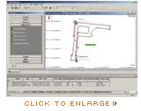
Intuitive Handling of Graphical Data
The innovative approach to presenting survey data in graphical and tabular form makes post-processing with GNSS Solutions a simple and enjoyable experience. Any collection of data can be viewed in different forms through simple drag and drop operations.
New Raster Maps Support
The capability to import raster or vector map formats enables you to combine background maps with land survey projects and plan and prepare stake out missions in the office.
Flexible and Adaptable to Local Requirements
Install English, Spanish, French, German, Russian or Chinese to accommodate the regions in which you work. Numerous mapping projections and local coordinate transformations are available so you can easily modify reports to comply with local and national standards.
Cross-compatibility with a wide range of formats including OpenGIS enables easy data flow to numerous GIS systems. |
|