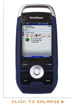
MobileMapper 6 is an affordable and easy-to-use, professional GPS/GIS handheld receiver. It provides a complete set of all necessary features required of a mapping device for anyone who needs productive data collection and efficient asset management in the field.
Performance GPS
MobileMapper 6 GPS engine provides professional accuracy in real time and post-processing.
This SBAS-enabled high-sensitivity GPS receiver computes and updates your position even in difficult conditions, such as under tree canopy and in urban surroundings.
Versatile Mobile GIS Solution
The MobileMapper 6 comes with Microsoft Windows Mobile 6 operating system, a color touch-screen, and it has Bluetooth for wireless connectivity. You can collect GIS/GPS points and maps via the GIS application of your choice: either a third party software or the proprietary Magellan Mobile Mapping application. You can also navigate, get your direction from the integrated e-compass, and communicate wirelessly.
Field-proven Rugged Design
MobileMapper fits comfortably in one hand and weighs less than eight ounces (224g). MobileMapper 6 is made for intensive outdoor use and can be dropped in the dirt or into water again and again without harm. It keeps working, and you won’t lose any data.
Feature-rich Mapping Device
Embedded speaker and microphone make it easy to record audio files, for a rich archive of locations and projects. You can take pictures using the integrated 2-megapixel digital camera, use the e-compass to determine the camera orientation at the time the picture is taken, and use other Windows Office Mobile applications, all with a single device.
Software Options
Mobile Mapping Application:
Magellan software provides easy-to-use and simple yet professional and effective GIS data collection capabilities. You can select this optional Mobile Mapping application to create and update maps for analysis and maintenance in a standard GIS system.
MobileMapper 6 Office:
Use this software option to differentially post-process raw GPS data collected with the Magellan Mobile Mapping software. Through post-processing, the positions of every GIS feature you collect in the field can be improved to 1-2 meter accuracy.
|